I have been asked if I’m ready for the ride. I have been putting in miles of course but past experience has taught me that mother nature has a way of nonchalantly unmaking even the most meticulously laid plans. With that in mind it should be noted I have not the first clue what I’m getting us into. Yesterday I rode 100 miles. Here are some stats from that ride. Firstly here is a graphic of the elevation gain over the 6 hours.

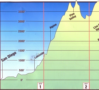
The highest altitude attained was 751 feet which was actually the start and finish point in Urbana. The lowest point was 640 feet somewhere between Tuscola and Arcola. This finally settles the argument once and for all that Urbana isn’t in the foothills of Mt. Flat. It actually is the summit of Mt. Flat. I practically felt my ears popping as I rode into town on First Street. The cumulative elevation gain for the entire 100 miles was 390 feet. So am I ready for the ride? Our goal for the first day of the actual ride is to get to Pine Valley. This is the elevation profile of the first 50 miles out of San Diego. That’s 0 to 4,000 feet.
 Am I ready for the ride? Sure. Just like someone who has read “What To Expect When You’re Expecting” is ready to have a baby.

I’ve had some experience riding the Mountains in Northern California. One thing that I’ve learned is that you keep your head down, don’t look for the summit. Just keep your legs moving and try not to stop on anything steeper than 8%. Otherwise it’s difficult to get going again. Oh, and enjoy the downhill 😬🚴
LikeLike
The summit of Mt. Flat. Love it.
On another subject: If anyone is on twitter, I suggest using #RaysLittleRide as a hashtag.
LikeLike
We have #rayslittleride and #heaintfuckindeadyet.
LikeLike
you really do have a knack with words… the analogy with the book is precious…. so so precious…
LikeLike
I LOVE the analogy. Thanks for making me laugh! You rock!!
LikeLiked by 1 person
It goes without saying that Mama Rae ROCKS too. Love you guys.
LikeLike
Looking at the profile of the first 50 miles and seeing that you made that 4,000 ft climb on day one – it seems clear that you will make it all the way Ray – you are ready!
LikeLike